- Balance
Between Food Security & Natural Species
- As Peak
Oil and Climate Change create
urgent needs to establish local food growing in The Grove, the focus
shifts from regenerating bush with native species to plants which
produce food in sufficient quantities and nutritional types to meet
community needs.. At the same time, The Grove is blessed with natural
features (forests, creeks, species) which have their own needs and
values to all of us. There are discussions to be had about how to
proceed and where the balance lies. The benefits of carbon capture are
equally available through food-producing tree and palm species and
native species. There is competition between species for soil,
sunlight, nutrients and space, so choice and decision is involved.
Bioregions - The Grove is a natural catchment
area, nestled within the
D'Aguilar Range. It is a heart-shaped region, and is visible 'from
space' - trying looking on Google Maps.
- Height
above sea level
- The Grove is between 56 metres above sea level (where Cedar Creek
and
Kedron Brook join) and 414 metres above sea level at the top of the
range (Camp Mountain 414 metres). A 200 metre contour runs through a
large part of Upper Kedron, with one 206m peak in Ferny Grove. Unnamed
peaks are at 206m, 215m, 245m, 309m and 300m.
- The D'Aguilar Range begins in the western suburbs of Brisbane,
and
reaches north to the township of Woodford. It is a vast bushland area,
including Brisbane Forest Park which reaches into The Grove.
 This map is taken from a contour map of the region, and has been simply
coloured to try to identify the mountains and waterways and roads. It
is noticeably heart-shaped (on its side).
This map is taken from a contour map of the region, and has been simply
coloured to try to identify the mountains and waterways and roads. It
is noticeably heart-shaped (on its side).
My
Neighbourhood Map
Use this tool to get a contour map with heights above sea level by
selecting the Suburb, and checking the Environment map layer. As you
can see, The Grove is well above sea level.
Wish
list: For the artists in The Grove to create a pictorial
representation of The Grove around the themes of its mountains (on 3
sides), its forests, its waterways and its shape which is even visible
from space.
Wish list: For photos taken within The Grove to add to the
website - special views and places, species, waterways, events
Brisbane City Council's
Cityplan
2000 includes Ferny Grove and Upper Kedron in Chapter 4.
This plan shows:
- Habitat areas and ecological corridors to be preserved (to Mt
Nebo and Brompton Rd)
- Landscape trees that must be retained (51 Ross Rd (hoop pines,
silky oaks, fig trees, foambark), 458 Levitt Rd (bunya pine), 433
Levitt Rd (crows ash), 298 Levitt Rd (hoop pines), 48 McGinn Rd (hoop
pines, bunya pine, silky oak, fig trees)
- Corridor link parks enhancing biodiversity and waterway function
(Cedar Creek to Bellbird Grove and Kedron Brook at Keperr Picnic
Grounds)
- The very large amount of land in Upper Kedron that is set aside
as waterway corridors around Cedar Creek.
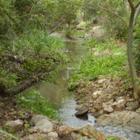
Catchment
Management
Cedar Creek
Kedron Brook
The photo in the header of
Transition The Grove webpages is
a photo of Kedron Brook.
- Snakes
- Queensland Reptile and Amphibian Club Queensland
Museum, South Brisbane, Queensland, Theatre level 2 every 2nd Wednesday
of every second month at 7.30 Contact Secretary Alma Searle +61 7 3200
0266
- Snakes are out in force. A record number of
snake bites (64 this year in Queensland) has resulted in a warning.
- Take
extra care to avoid snakes at this time of year. 3 found in Patricks Rd
School grounds recently.
- If bitten:
Pests
Department of Natural
Resources and Mines Pest Management and Pest fact sheets
- Freshwater mosquitos
- Cane toads
- Feral cats
- Wild dogs
- European fox
- Red-eared slider turtle
- Contact Department of Natural Resources and Mines 1800 999 367
- Rabbits
- Yellow crazy ants
- Common myna birds
- European honey bees
- Deer
- Exotic aquarium fish (guppies, platys, swordtails,
mosquitofish (gambusia), tilapia, carp/goldfish)
- Ring Department of Primary Industries and Fisheries to report
or identify 13 25 23
- Exotic aquatic weeds
(salvinia, senegal tea, alligator weed, water hyacinth, water lettuce,
cabomba)
- You can help by using only native fish in your aquarium (crimson
spotted rainbow fish, pacific blue eye, firetail gudgeon, eel-tailed
catfish). They are great for reducing mosquitos.
- Local Fauna
- What
is Biodiversity?
- Invertebrates
- Worms
- Shovel-headed garden flatworm Bipalium
kewense
- Blue garden flatworm Caenoplana coerulea
- Planarians
- Gordian worms (wireworms, horsehair worms) Gordiuss spp. Chordodes spp.
- Earthworms Oligochaeta,
Digaster spp., Amynthas spp., Tubifex spp.
- Leech Chtonobdella whitmani
- Land snails and slugs
- Fastosarion virens
- Nitor pudibunda
- Sphaerospira mattea
- Xanthomelon pachystylum
- Meridolum gilberti
- Papuexul bidwilli
- Triboniophorus graeffei
- Deroceras panormitanum
- Lehmannia nyctelia
- Limax maximus
- Vaginulus plebeius
- Laevicaulis alte
- Bradybaena similaris
- Helix aspersa
- Spiders
- Spider
species in The Grove
- Scorpions
- Large Brown Scorpion Nocturnal.
Sting delivered by tail, not known to be dangerous
- Small Mottled Scorpion Sting
not known to be dangerous
- Mites and Ticks
- Mites
- Ticks Dangerous paralysing
toxin is released by adult female Scrub Ticks after several days
feeding.
- Pseudoscorpions
- Harvestmen
- Centipedes and
Millipedes
- Centipedes Bite causes
severe pain which may last for several days. No deaths recorded
- Millipedes. Favorite food of funnel-web spiders.
- Pill Millipedes
-
Vertebrates
- Freshwater fish
- Lungfish
- Exotic fish
- Frogs
- Cane Toad Bufo marinus
- Eggs are unlike those of native frogs. They resembel a long
string of egg noodles. Tadpoles swim and feed in schools.
- Cane Toads are toxic at all stages of life. Care should be
taken when handling because of toxic skin secretions.
- How you can 'grow' Frogs in the Backyard
- Would you like to have
your own frog pond in your backyard? Jenny from Queensland
Frog Society will tell you how.
Royal Geographical Society of Queensland, 237 Milton Rd, Milton (UBD 21
L1) 7.30pm Tuesday 23 March 2010
- Freshwater turtles
- Eastern Long-necked Turtle
- Broad-shelled River Turtle
- Saw-shelled Turtle
- Brisbane Short-necked Turtle
- Lizards
- Geckos
- Asian House Gecko
- Thick-tailed Gecko
- Robust Velvet Gecko
- Spotted Velvet Gecko
- Dragons
- Tommy Round-head
- Nobbi Dragon
- Southern Angle-headed Dragon
- Eastern Water Dragon
- Common Bearded Dragon
- Lizards
- Goannas
- Gould's Goanna
- Lace Monitor
- Skinks
- Verreaux's Skink
- Carlia pectoralis
- Carlia schmeltzii
- Lively Skink
- Ctenotus arcanus
- Eastern Striped Skink
- Copper-tailed Skink
- Wall Skink
- Pink-tongued Skink
- Major Skink
- Land Mullet
- Tree Skink
- Narrow-banded Sand-swimmer
- Broad-banded Sand-swimmer
- Elf Skink
- Martin's Skink
- Tyron's SKink
- Eastern Water Skink
- Bar-sided Skink
- Secretive Skink
- Couper's Skink
- Grass Skink
- Burnett's Skink
- Fire-tailed Skink
- Ophioscincus ophioscincus
- Saproscincus rosei
- Blue-tongued Skink
- Snakes
- Birds
- Birds
surveys
- A Native Bird Rescue Service is operated in Ferny Hills by Len
3351 4068 or 0417 193 573
Bird
species identified in The Grove
- Monotremes and marsupials
- Bats
- Rats and mice
Soil Profiles
Hills & Mountains
- So far we have not been able to
identify names for most of the
peaks in The Grove. The most significant one is Camp Mountain (414
metres) at the north-westernmost point of The Grove. Other peaks stand
at 206m, 215m, 245m, 309m, and 300m (McAffees Lookout).
Bushcare
Fire Management
Geology
The range offers striking contrasts with its
diversity of habitats
and plant communities, providing sanctuary for around 90 species of
reptiles and amphibians, 65 species of mammals and 270 species of
birds. There are remote gorges, sheltered pockets of subtropical
rainforest, expansive forests and spectacular views.
Around the 1860s gold prospectors staked their
claims on
quartz-bearing rock in the hope of striking it rich. The mines produced
only small amounts of gold and were abandoned in the 1950s. Old
mine shafts and adits are still there along the Golden Boulder track at
Bellbird Grove.
The forest is crossed by walking, bike-riding
and horse-riding
trails, and some wild camping areas (permits needed).
Domestic animals are not permitted in the park.
Carry adequate drinking water and a mobile
phone. Drinking water is
not provided on park.
Forests, Trees and Plants
- The Grove is well-supplied with forests and plant species.
There are 3 local bushcare groups.
National Parks
Back To Top
This page last updated